“Districts are structured with nodes, defined by edges, penetrated by paths and sprinkled with landmarks. Elements regularly overlap one another.” – Kevin Lynch
What is Imageability of a city?
Elements forming the ‘City Image’
The “public” image of a city is the overlap of many individual images. Such group images must exist within the city if it is to be successful in communicating its own identity and possessing its own imageability.
- It is defined by broadly:
- Paths
- Nodes
- Districts
- Landmarks
- Edges
- Element inter relationships
Paths:
Paths are channels along which an observer customarily, occasionally or potentially moves. Eg: streets, avenues, walkways, canals etc.
People observe the city while moving through them; the other elements are arranged and related along these paths.
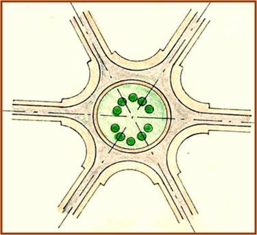
Nodes :
They are strategic spots in a city into which an observer can enter, and which are the intensive foci to and from which he is traveling. Conceptually, they occur as small points in a city image, but in reality they are large squares, traffic rotaries, extended linear shapes or even entire central districts at the city level .
Landmarks:
They are another type of point reference (as nodes), however in this case the observer can’t enter within them. Usually they are simply defined physical objects like statues, buildings, signs, stores or even a mountain. They are identified by singling them out from a host of possibilities.
Districts:
They are sections of the city, conceived of having two dimensional extents, which the observer can mentally enter and which are recognizable as having some common, identifying character.
Edges:
They are linear elements not used or considered as paths. They maybe the boundary between two phases, linear breaks in continuity, an area or an element. E.g. shores, railroad cuts, edges of developed areas, walls.
Element inter relationships:
No element exists in isolation; elements are simply the raw material of the city image. They must be patterned together to provide a satisfying city form.
“Districts are structured with nodes, defined by edges, penetrated by paths and sprinkled with landmarks. Elements regularly overlap one another.” – Kevin Lynch
Image Type:
Images maybe developed in various ways. Generally, there are 5 image types:
- Images developed along familiar lines of movement.
- City edges as prominent image elements.
- Image as a basic pattern which repeats itself.
- Image as a basic pattern which repeats itself.
- Images as a set of adjacent regions.
- Images developed from a familiar node.
Lutyens’ Delhi:
In order to understand the imagability of Lutyens Delhi, it is imperative to know its history and why the site was chosen.
History:
The primary concern for the transfer of capital from Calcutta to Delhi was to locate a more durable and subtle public opinion: the intention was to express the achievements possible under the British Raj and as a stamp of the autocratic rule.
Criteria for Site Selection:
The committee which was setup to choose a site recommended that if the imperial capital is to be favorably situated to present an effective appearance, it should be approached along a line of rising ground. Lord Harding chose the Raisina Hill for locating the viceroy’s palace because:
- It was a well drained.
- Constituted of slopes and plains between the ridge and the river.
- Its eastern and southern margins were studded with monuments of vanished empires.
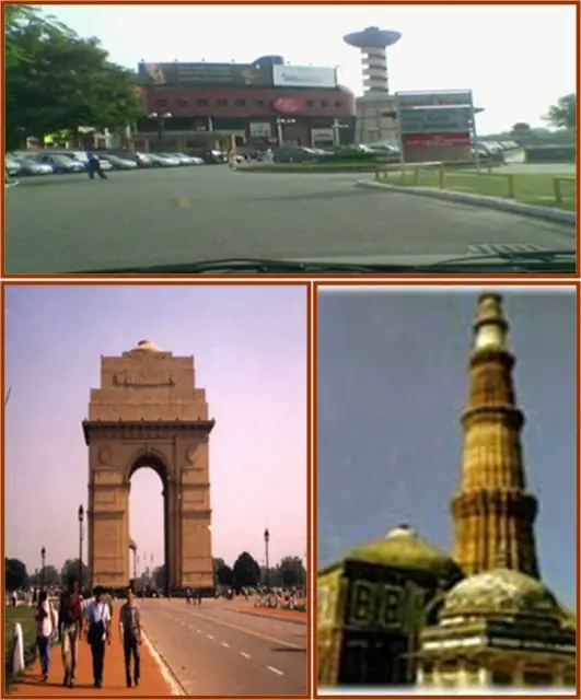
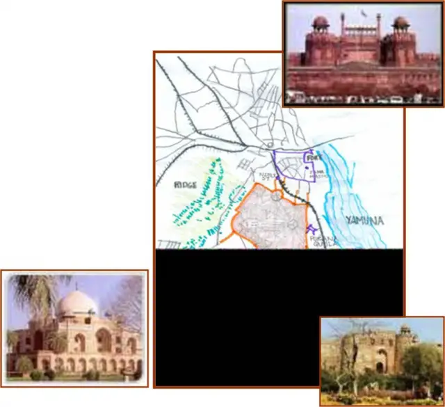
- A broad crescent from Shahjahanabad and Kotla Firoz Shah, south to Tughlaqabad and the Qutub with tombs of Safdarjung and Lodhis as well as Jantar Mantar in the foreground could be viewed from the site.
Site location:
Shahjahanabad was towards the north.On the west of the site, the natural limit was the ridge.The river formed the eastern limit.On south a line drawn from a point on the ridge, west of Talkatora to Safdarjung tomb and then due east to the river marks the southern limit. The tract between the line and the Qutub is designated for further expansion.
Intentions of the Layout:
- The attempt was to include all natural and historical wonders in the new city.
- Lutyens Delhi was planned on the most spacious garden city lines with the great avenues decorated with classical buildings with lush landscape.
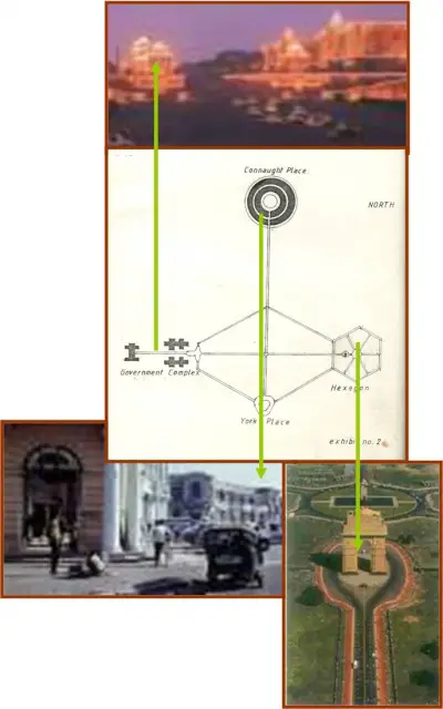
LAYOUT OF THE CITY
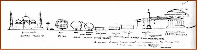
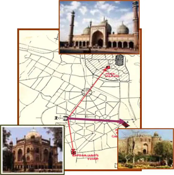
The layout of Lutyens Delhi was governed by three major visual corridors, linking the government complex with :
- Jama Masjid
- Indraprastha
- Safdarjungs Tomb
Processional Routes:
The principle parkway, Kingsway, forms the main processional route which leads from Purana Quila, through the ceremonial gate, towards the forecourt at the base of Raisina Hill.
Crossing this Parkway, at right angles is a N-S axis , the Queensway, terminating in Connaught Place in The North. At the junction of the two main avenues are four large buildings- Oriental Institute, The National Museum, National Library and The Imperial Record Office.
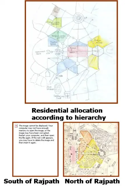
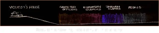
RESIDENTIAL ALLOCATION:
- Within the hexagonal grids areas were located on criteria of race, occupational rank and socio-economic status.
- The North-East axis forms the cities main business avenue.
- South-West of station –residences of local administrators and European clerks.
- To the West, between Talkatora Gardens and Paharganj- Residences of Indian clerks.
- Vicinity of Raisina Acropolis- housing for council and other higher officials.
- North And South of Kingsway- Senior gazzetted officers.
- East avenue around the hexagon –Indian Princes(princes Park).
- S-W of Viceroys palace- The Club. Adjoining land was reserved for Golf and Race course.
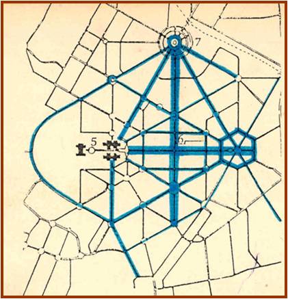
ROAD NETWORK:
Besides the major Pathway, all avenues ranged from 18m to 180 m in width. The original design of the road network was capable of accommodating 6000 vehicles, however these avenues, had the potential of increasing their carriageway-the reason why the road layout has survived till today.
In general the road network consisted of diagonals and radials, at 30 degree/ 60 degree angles to the main axis, forming triangles and hexagons. Points of climax were placed along the avenues after every ¼ or ¾ mile as beyond this the perception of focal points is greatly reduced.
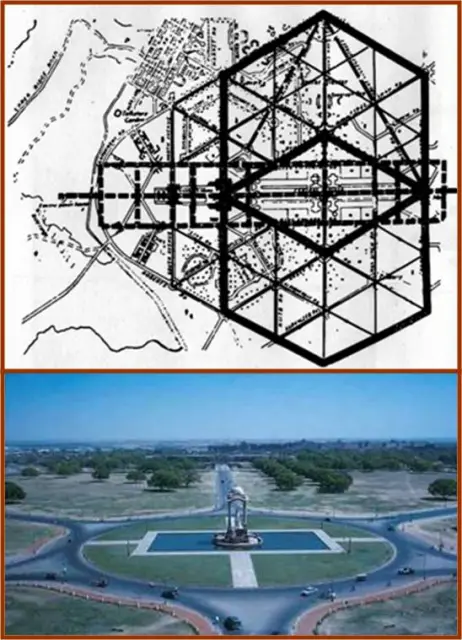
The interlocked duality of contradictory grid and radial diagonals heightens the visual impact of each element and gives the entire plan a complex and creative tension not otherwise possible.
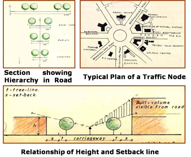
Image Elements of Lutyen’s Delhi:
- Paths
- Nodes
- Landmarks
- Edges
- Element inter relationships
PATHS :
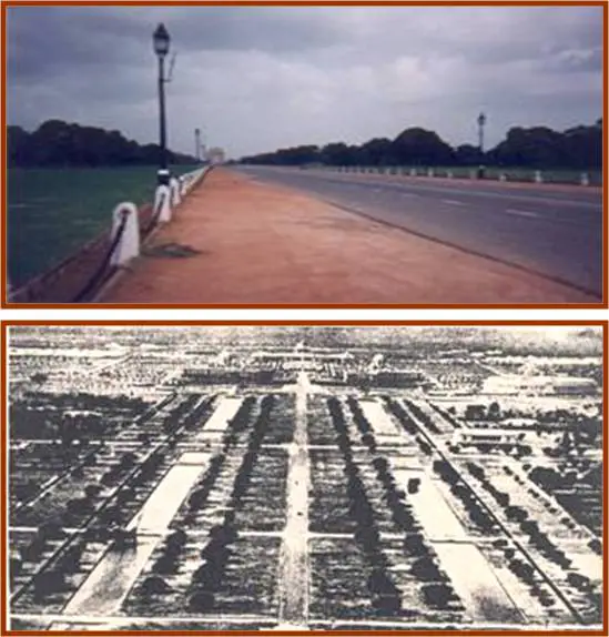
Avenues spread out in descending hierarchy starting from Kingsway and Queensway.
Continuity of spatial hierarchy, façade identity, visual scope, usage, paving and planting, formality and activity lend it a unified city image.
But this continuity also leads to confusion as most paths look the same.
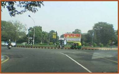
NODES:
Roundabouts were placed at the path intersections.
They functioned as origins and destinations for avenues.
At times 6-8 avenues converged at a node. Incorporation of some monuments within these nodes generated a stronger city image.
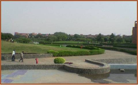
The garden character of the city was carried through in and around these nodes.
EDGES:
The ridge forms its western edge, while the Lodhi Gardens and other greens also mark its boundary. Other parks separated Imperial Delhi forming a green belt that virtually ringed the capital city.
LANDMARKS: were essentially located at important foci. E.g.: Teen Murti house, the club, the old monuments etc. They express the character of Lutyens Delhi and form its associative image ability.
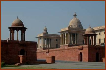
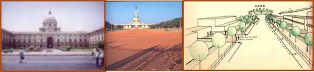
GOVERNMENT COMPLEX:
The entire city was focused on the government complex, which functioned as a symbolic and physical city centre.
CONNAUGHT PLACE: It was the C.B.D. The radial pattern of roads converging at this place and the circular form of the node further enhanced its importance.
INDIA GATE HEXAGON : The point of convergence of major roads leading in from north and south Delhi.
YORK LACE: Termination of Queensway
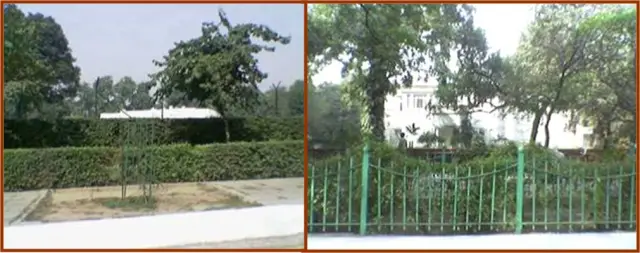
BUNGALOW AREA:
An area of low density development comprising of government and privately leased bungalow (originally reserved for senior gazetted officers).
They were surrounded by walls enclosing large gardens, with high proposition of trees and shrubbery, contributed in forming a thematic unit with the residential district
Maximum ground coverage of 16% and an F.A.R of 23 allowed dwelling units of 7000-8000 sq. ft. in area with a maximum height of 25 feet.
- Social hierarchy was used to establish thematic contrast . Physical elements within were used to convey the status of the residents
- Social hierarchy was used to strengthen the image.
- The closer the road/ path is to the Government house the greater is its width.
- Status was communicated by elevations, size of compound and dwelling, width and name of road and area, quantity and type of vegetation, size of gates and nameplates etc.
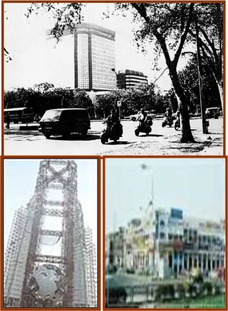
Changes In The Bunglow Area Near The Central Business District (C.P.):
Most residential plots in the vicinity of Connaught Place have been taken over for commercial use. High rise towers have now occupied almost all of the bungalow area.
Because of this the garden city environment is no longer present. Today the built form dominates the streetscape and high buildings have dwarfed the trees and ruined the formalities of avenues.
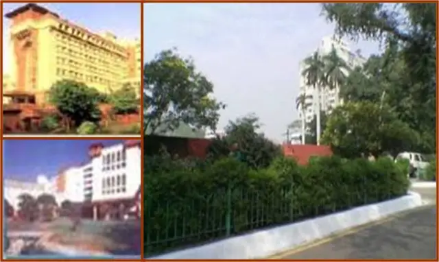
Increase in ground coverage and parking demand have been responsible for hard surfacing of the previously green set backs. These paths are now merely liner bus terminals.
The varied architectural style leads to thematic confusion and thus ruins the original character of this bungalow area. The loss of garden city character, visual scope and formality have led to a blurred image.
The New Face Of Lutyen’s Delhi:
Causes for Change:
Master Plan Proposes higher densities due to increasing pressure on land leading to new development.
Functions adjusted to suit the form.
Master Plan Recommendations:
- Re-densification of plots in order to accommodate government officials working in the secretariats and Lodhi Road Complex.
- Increase in Resource generating activities like commercial and community facilities.
- Group Housing on plots larger than 1 acre.
The objectives of the Master Plan were to redevelop the Bungalow area so as to preserve the character of Lutyens Delhi, however this has not happened
Our Suggestions:
The overall plan may incorporate features that lend thematic unity to the district. It should give rise to a group image which should emerge from the overlap of images generated by individual elements.
Within a particular zone the elements should possess a sharp image by themselves, and yet focus on a central theme, towards which the thematic gradient should converge.
This presentation was created by: Abhishek Sharma,Kanika Bhargava,Shinjini Mehta & Vanit Gupta
its really helpful and very
its really helpful and very well made presentation
thank you guys