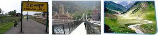
- Dehradun is the capital city of uttaranchal.
- Located at altitude of 640 mts above sea level.
- Dissected by seasonal streams and nallahs (khallas).
- City slopes gently from north to south and south-west (gradient – 1:37.5 ) i.e. varying from 1000 – 600 mts.
CLIMATE
- Temperate climate.
- Moist climate, not so liable to extreme heat and cold.
- Due to its altitude and close proximity to the himalayas, cold weather commences earlier and lasts longer than in plains.
- Annual rainfall is about 80 inches.
TOPOGRAPHY & PEOPLE

- The drainage of the city is borne by the two streams.
- The bindal rao.
- The rispana rao.
- The direction of flow of streams and nallas in the eastern part is north to south and in the western part it is north to south-west.

People of dehradun are actively engaged in the following activities:-
- Rice farming
- Tea plantation
- Leechi plantation
- Sericulure
- Limestone mining
FAIRS:
JHANDA FAIR: held every year at the guru ram rai durbar in dehradun city on the fifth day after holi in the sacred memory of the guru.

BISSU FAIR: this fair marks the harvesting season, reflects the culture and tradition of the jaunsari tribe.

MAHASU DEVTA’S FAIR: local fair of the jaunsari tribe where mahasu devta ( the deity) is taken out in a procession..

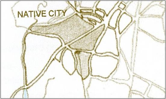
NATIVE CITY
- This settlement initially came up when ram rai guru of the udasi sikhs, on being ordered by aurangazeb to retire to the wilderness of the dun, had pitched his tents here in the khurbur locality and had also built a gurudwara.
- Thus, the name of this city has been derived from the term ‘dehra’ which is a corruption of the word ‘dera’, signifying a temporary abode or a camp. also, ‘dun’ means the lowlands at the foot of a mountain range.
GROWTH OF THE CITY UNDER THE BRITISH
- Apart from reasons of ancient history, dehradun acquired a certain importance with the coming of the british in 1814.
- Settlement was favoured there because of its favourable climate.
- During 1822 to 1828 new roads were develodped and improvements were made on the infrastructure.
From 1830 to 1960 a great deal of development happened:-
- Cantonment.
- Tea industry.
- Chakrata.
- Forest rangers institute (1884).
- Railways ( 1900 ).
- Forest research institute (1928).
- Paltan bazaar (from clock tower to gurudwara).
- Clement town and the ordnance factory.

THE POST-INDEPENDENCE PERIOD
There was no effort to channelize the haphazard growth and consequently, the city faced many problems like-
- Lack of bye-laws
- Congestion in the central core of the city
- Uncontrolled traffic and transportation
- Slums sprang up on beds of seasonal streams
- Shops encroaching on the streets


SETTLEMENT
50.5% of total population distributed in urban areas
49.5% of distributed in rural areas
There is a characteristic scattered settlement pattern owing to the physical configuration of the valley.
though the smaller sized settlements outnumber the larger ones most of the population is concentrated in those having a population of more than 500 prefarably range of 2000 to 5000.

There are 3 urban and 345 rural settlements.
3 main urban settlements :
- dehradun urban agglomeration
- rishikesh ( east )
- vikas nagar ( west )
the dehradun urban agglomeration ( 6423 hectares ) consists of dehradun municipal area, forest research institute, adhoiwala outgrowth, dehradun cantonement, clement town and rajpur town.
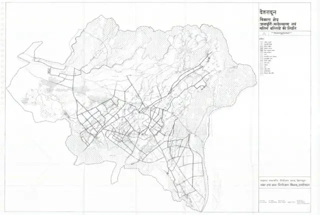
ROAD NETWORK
The clock tower round about is an important junction of the 3 major roads namely
- rajpur road
- chakrata road
- paltan bazaar road

- Rajpur road forms the main motorable road to mussoorie .it is an important axis running through the city.
- All the major roads further divide out into a number of secondary streets which are narrower.

INSTITUTIONS
Apart from performing an administrative function, it is an important educational centre in india. it has many city and regional level institutes, technical institutes and national level institutes.
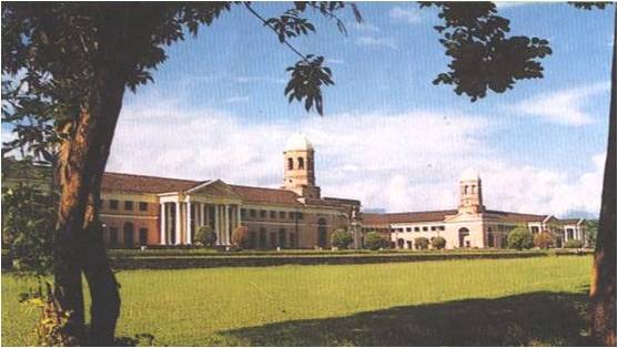
FOREST RESEARCH INSTITUTE (FRI)
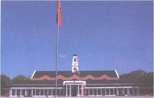
INDIAN MILITARY ACADEMY(IMA)

DOON SCHOOL
NEED FOR THE MASTER PLAN
The dehradun settlement is mostly of the mohallah type (organic growth) where we can see the clear distinction between the native city and the collonial development.
In the post-independence period there was unprecedented growth in the population and the area. there was no effort to channelize this haphazard growth resulting in problems like :
- Uncontrolled traffic and transportation
- Proliferation of slums on lowlands and beds of seasonal streams
- Encroachment of commercial activities
- Congestion in the central core
- Haphazard location of lime-kilns led to environmental pollution

OBJECTIVE OF THE MASTER PLAN
- Creating urban rural centres in the villages surrounding the city
- Relocating wholesale markets from the city to the saharanpur road.


URBAN RURAL CENTRES AROUND DOON
For planning regulation, control of development activities and to decongest the city centre.
Thus, the mdda ( mussoorie dehradun development authority ) formulated a master plan for the city of dehradun.


The drainage of the city is borne by two stream:
- Bindal rao
- Rispana rao
Direction of flow of streams and nalas is from north to south and southwest.

Showing cant area, River,Proposed road,Railway line,Tea garden
PROBLEMS FACED BY THE PEOPLE
- The cars are literally parked onto the pavement as the seating has been removed and the road widened to carve out a parking space for the cars.
- When the seating existed, it acted as a barrier to the vehicles and also as a retreat for people to sit and enjoy the view of the hills in the evenings.
- The road is 12 m wide with no divider and no red light along its entire length which makes the traffic unruly and the road difficult to cross.
- Constant menace of hawkers and tempo drivers waiting for passengers along the parking. this is because no public transport can go upto the clock tower from connaught place.


CHANGES IN THE BUILDING
- Due to shortage of space and shopkeepers wanting to expand, the verandahs have been encroached upon.
- Though the footpath still exists, now people have to stand on it while shopping thus interrupting the smooth flow of pedestrian movement.
- Balconies on the first and second floor have been covered up to increase living space inspite of being illegal according to the bye-laws.

STREET STUDY
STUDY OF JHANDA MOHALLA
- The residential settlement which developed around the gurudwara which guru ram rai constructed is locally called the jhanda mohalla.
- The sarovar is a rectangular water tank with roads on all 4 sides with residences behind and gurudwara along eastern edge. towards the north is the paltan bazaar road.
- Initially the sarovar catered to allthe water requirements.
- As the population grew, area of habitation expanded, the sarovar not being sufficient to meet the requirements, was neglected and dried up.


PALTAN BAZAAR
- This market was a part of colonial develpoment and thus designed for mixed use keeping in mind the people using it.
- Ground floor : shops.
- First floor : residences.
- During daytime – lively market place.
- In the evening – transforms into quiet residential lane.
- No vehicular movement allowed on the paltan bazaar road.


CHAKRATA ROAD
- The road starts from the clock tower,goes into the chakrata tehsil.
- Tilak road joins it just before the bindal rao in the connaught palace.
- The connaught is a linear market with shops on either sides and two cinema theatres.
- While walking down from the clock tower, the buildings on the left (the new connaught place) constitute the mansaram building. the buildings opposite to this building are a mixture of old and new buildings.


MANSARAM BUILDING
- Three storeyed building, with shops on the ground floor, residences on the first and the second floors, built after removing tes gardens.
- Ground floor had verandahs and the upper two floors had balconies.
- There were a set of two adjacent buildings with playground in between. these buildings were bought by the lic who built their own offices where the playground was supposed to be.
- A series of courtyards at the back to let sunlight into the apartments which are entered from the rear side of the building and not directly from the chakrata road.


AREA OF CONCERN
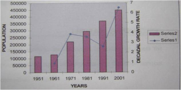
In Dehradun the population is increasing but the development of basic urban services is not provided at the same pace and with the capital function the city is not ready for the induced demand that would become. the increasing urbanisation should bring more good than problems to the city.
- Can the city add on to more population which is an inevitable outcome with it becoming the capital?
- Or is the beautiful gateway to uttaranchal being choked to a slow inevitable death?


DEHRADUN- THE CAPITAL
Dehradun , because of its size and better linkage to delhi and other towns in the region was declared as the capital of the region without extension of the existing urban area.consequently the decision had impact on existing activities and infrastructure as well as the existing built-up areas.
- Various private companies and companies have opened their branches in the city generating employment for many.
- But the growing consumerism has also given rise to ugly chrome and glass buildings which are slowly eating away the beautiful old colonial bungalows of the city.
- The increased traffic and power,water and other services are not just enough to serve all the residents of the city.

WHERE IS THE TOWN HEADING TO
- Uttaranchal is a small hill state. whatever resources these hills have the government does not give permission to the people to use them. this system has made the people of this state poorer.
- The economic engine of this city is the various offices generating employment for numerous people. this dependency on the private companies has made the township less powerful as the money is coming from outside.
- Major densification has taken place in recent years without augmenting the infrastructural facilities.


URBAN ENVIRONMENT ISSUES
The city faces various problems in terms of supply facilities , for which area is inadequate although the source availability and treatment facilities is adequate. thus the remaining population unserved by the urban services faces problems such as:
- Environmental degradation.
- Unhygienic living condition.
- Forest cover has diminished over time.
- The horticulture act has been misused for the decimation of dehradun’s lichee orchards.


IMPLEMENTATIONS TO BE DONE
- To help the city reach new heights of success,community involvement is a must for creatinglong term and wide ranging benefits.
- The hinterlands of the city must be developed and various activities like industries,
- Communities shifted there to reduce the burden on the core urban areas.
- Roads need to be widened and parking areas defined. although traffic signals have been installed at various important junctions but 90% do not function. thus,the maintenance of public property is an important concern.
- Slums should be removed from various river beds and rehabilitated elsewhere.
- There need to be planned open areas and recreation areas for the residents.one facility that the city completely lacks.
- There should be limited access lanes to the core urban areas. the proposed ring road needs to be completed.
- Merciless cutting down of trees need to be checked,as well as the breaking down of the old buildings.
The city needs to undergo “urban renewal”. with a steadily increasing quality of life, a booming economy and consumer market and by virtue of the fact that it is the state’s capital, cultural and intellectual life in the city is growing as well.
This page should be
This page should be revised.Information is brief and to the point which is good but data if revised would give us a better knowledge about Doon.Also add pictures of places like guchhu pani,beejapur canal,resorts that have come up west of jakhan by the riverside and cricket academy not to be missed