“Amritsar“, which literally means, a pool of nectar, is known as the city of the Golden Temple also which stands amidst a sacred water tank, from which the name of the city was derived. The Golden Temple is one of the most sacred shrines of the world. Hence the city assumed much importance. But the city has much more to its glory than just being another pilgrimage centre.
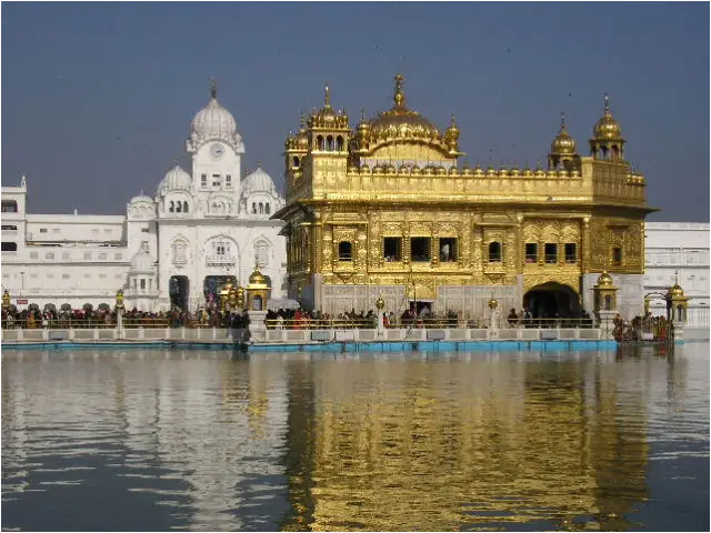
The Golden Temple, Amritsar
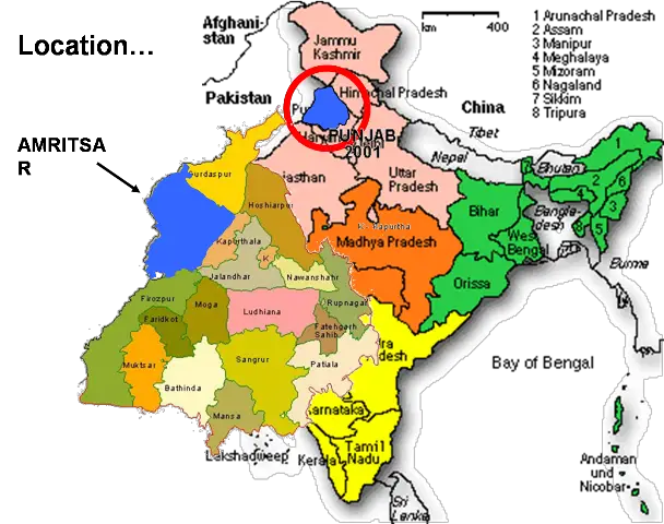
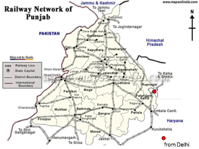
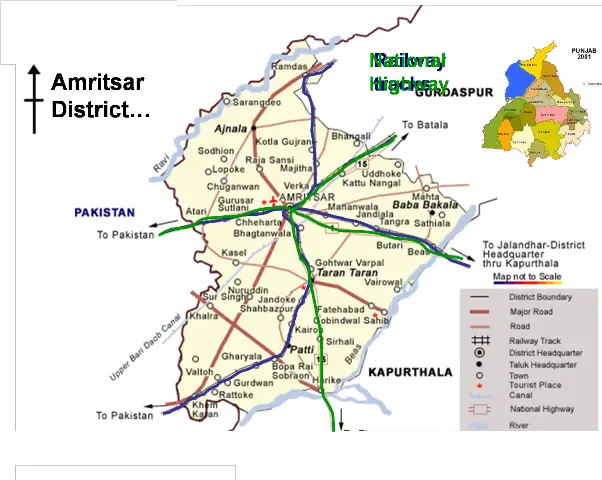
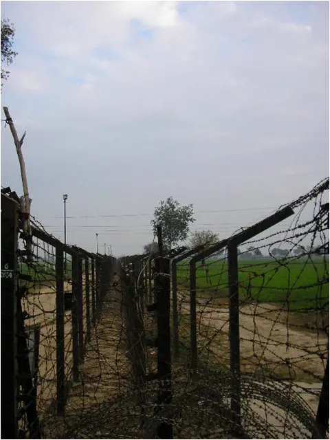
Amritsar is situated at 31’37”N latitude and 74’55” E latitude and lies between Ravi and Beas rivers. It covers an area of 1300 sq. miles. The city is 17km from Indo-Pak border and 400km from Delhi. Amritsar is well connected with other parts of the country by rail road and air.
Topography
The city’s average height above mean sea lvl is 755feet. It lies in a saucer shaped basin. On account of small gradient and a number of natural and artificial obstructions the rainfall cannot flow rapidly which results in flooding of large parts of urbanisable area towards north.
Climate
The climate of Amritsar region is hot and arid type with very hot and long summers and cold winters. Hottest day of May and June have recorded a temperature of 116 F (47 C). January has recorded the lowest temperature of 29 F (-2C).Rainfall : Maximum rainfall occurs during July-September from the monsoons. The average rainfall is 61.1 cm.Wind Direction : The most prevailing wind direction is north -west.
Demography
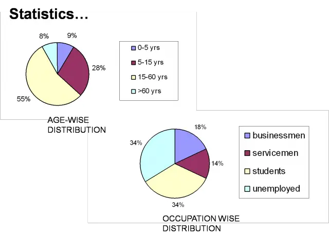
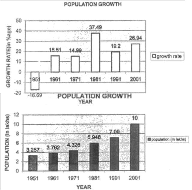
Present population of city (municipal area) is 10 lakhs.
A brief history..
The development of the city of Amritsar may be conceived in terms of six more or less clearly marked phases.
Foundation : In the first two hundred years of its history Amritsar was called Ramdaspur, or Chak Ramdas, or simply Chak Guru, because it was Guru Ramdas who under the able guidance of his predecessor, Guru Amar Das, wanted to found a township in a sacred spot where a tank had been dug in the year 1573 which is the present site of the umrit-sarovar. By 1577, the digging of the tank was complete. Devotees started coming from far and near. Some of them decided to settle down permanently in the fast upcoming township in the vicinity of the sacred sarovar. By 1581, This township became well established and came to be known as Ramdaspur. The first fifty years of its existence, in the late 16th and the early 17th century, saw its foundations well laid. Fairly well connected with the world out- side, it formed an island of autonomous territory in the Mughal Punjab, with its administration and control in the hands of Guru Hargobind.
Survival : After he left the city because of conflicts with Mughal administration, for more than a century the town did not grow any .more : in fact it had to struggle for survival.
Expansion : The Harniandir was constructed through a collective effort of all the leaders of the Khalsa. A few of them established their own forts in the town in all four directions. A walled locality with only one main gate, the katra provided all the security its inhabitants needed. The core was partly reconstructed and became more thickly populated. But a whole ring of forts with palaces, katras with their own markets and houses and some factories, and havelis with spacious gardens sprang up on all the sides of the town, which now came to be known as Amritsar.
Consolidation : Under Maharaja Ranjeet Singh, the city got consolidated as well. In the third decade of the century, the Maharaja started constructing a double wall with moats around the city to improve its fortifications. Twelve gates, with bridges on the moats, were made. In 1809, the Maharaja had constructed a fort outside the Lahori Gate, and named it Gobindgarh. The Maharaja used the fort for his residence also, before the Rambagh (now called ‘company bagh’) palace was completed in1831.
Colonial Rule : Around the early 19th century, in 1849, the British took over the city. One of the early measures of the British administrators of Amritsar was to remove its fortifications. A new wall only a few feet thick was constructed, eaving only a few old gates intact. In due course they built offices and houses for themselves and helped the Christian missionaries to establish their institutions in the city.
The Railway Station, the Town Hall, the Government School building, the District Courts, the Treasury, the Victoria Jubilee Hospital were all built in succession.
Post Independence : After partition of the country in 1947 the entire scenario changed and the city, which commanded the central position, now became a border town 28 km away from the international boundary. After independence the city bore a great loss because of riots. Large portion of the city was burnt down and about 150 m of city wall was burnt down. The specter of partition undermined communal harmony almost all over the country and Amritsar was no exception It had its share of arson, pillage and rapine. Though the city has now again grown up into a strong business and religious head quarter but being the border town it had to face bums of 1965 and 1971 war, which again affected the growth of the city. But one single factor that can appreciably accelerate its growth is a friendly and an open border.

Major events in the post independence period:
Jallianwala Bagh Incident
On April 13th the day of baisakhi a public meeting was announced to be held a Jalianwala bagh maidan close to the golden temple premises to asset the people’s right to assemble and protest against the Rowlett act which had come into operation on march 21st 1919 and it had generated angst all over India. But brigadier general dyer who had taken charge of Amritsar then decided to leash havoc on some 25000 men , women and children who had gathered there. As the machine guns started raining bullets the dead piled upon the dead and wounded upon the wounded. since there was a single exit (narrow passage) resulted in a stampede. Such a merciless massacre shocked the entire nation.
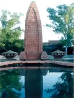
Today the place has become a pilgrimage of sorts, a symbol of Hindu Muslim unity, a hallowed spot where Indians shed their blood fighting for the freedom of their motherland.
Effects of Partition
In 1849 when the British had taken over Amritsar from then to 1947 till partition Amritsar hardly registered much development in terms of socio cultural issues. It had become a politically unstable state. After partition Amritsar could now look forward to a peaceful future. Although it lost upon its communal harmony and witnessed arson, pillage and rapine in the beginning, it soon started recovering from its wounds.
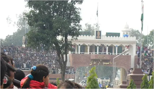
Since it was the only connection to Lahore which now went to the other side it became an important border city. But the growth of the city got hampered because of the now existing physical barrier. Although Amritsar lost upon a lot of things like fertile land and river and industries but it managed to strive forward to progress.
Operation Blue Star
Operation Blue Star was a code name given by the Indian government to an attack launched on the Golden Temple, the holiest shrine of the Sikhs. The attack, initiated on May 31st 1984, was one of the most inflammatory actions ever taken by the Indian government.
Government of India had implicated one Bhindrenwale, who was involved in a lot many terrorist activities in the state and arrested him in 1982, but he was released within two days. Then, in later half of 1982 Bhindrenwale moved to Golden temple complex where he setup his headquarters in Guru Ram Das Sarai. Indira Gandhi and government of India declared president rule in Punjab and deployed 4 division of Army through out Punjab, in a desperate attempt to flush out Bhindrenwale and his accomplice from Golden Temple complex.
Then it all started, proper commando operations followed, commandos supported by infantry and tanks and machine guns attacked the holy place. Curfew was imposed in the city. The operation itself led to the death of some 5000 people which included terrorists as innocent devotees who were trapped inside the complex. The city of Amritsar burnt for quite sometime in the wake of such a situation. It led to civil war and riots not only in the city but all over the nation. It was a big attack on the temple but a bigger one on the sentiments of the people.
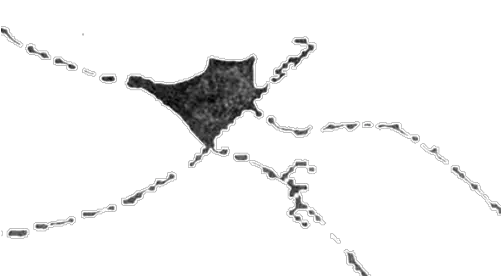
1628, The township of Ramdaspur around the sarovar.
1802,The settlement started to grow further in an organic way. The walled city came into existence and it became densely populated.
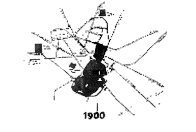
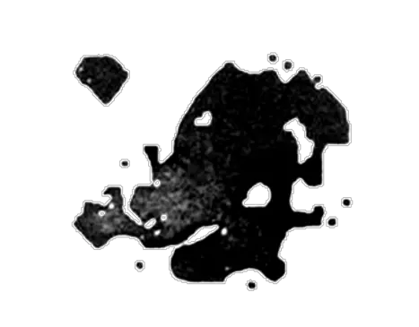
1900, The settlement spilled outside the fort area. British settlements developed outside and away from the core.
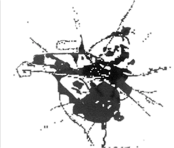
1947, Amritsar expanded in all directions. New settlements came along the GT Road and the Railway lines.
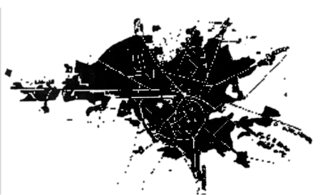
2000, the city becomes densely populated. The planned and the organic development has generated a complex growth pattern.
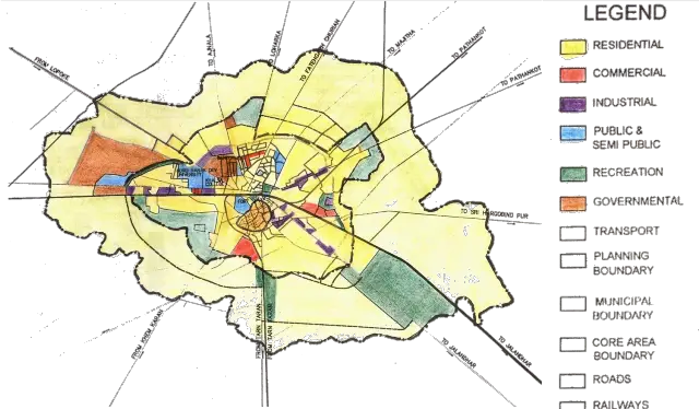
Land use map of Amritsar
LAND USE ANALYSIS OF AMRITSAR
- The land use of Amritsar is of mixed type. The map shows that more than 50 % is residential and commercial activity is only limited around 5-10%.
- As there is mixed land use, at least along the main roads, the commercial activity is happening in the ground floors and the residential on the upper floors.
- All the industries have come up along the main trading routes only for obvious reasons. The important educational institutes have also come up along the main roads.
- The main government institutes have been kept away from the city, towards the west.
- Recreational spaces have been kept towards the outskirts, around the periphery of the city.
- The growth of the city has occurred and would occur in all the directions- keeping the old fabric of the city, i.e. the walled city as the center of the urban sprawl.
- And it is on account of this central locational advantage and also because of the well established relationship of this central area to the new area through good accessibility- the walled city core – the city center functions well in the city context.
Core :
Core area = 340 ha
Existing population = 2 lakhs
Density =550 pph
The walled city forms the historic and traditional core of the settlement and has important landmarks like the golden temple, Jalianwala Bagh and Durgyana temple. The road all around the wall is the Circular Road. There are perpendicular roads originating at the wall gates. Inside the core these roads form spines for the settlement.
Land use map of Core
LAND USE PATTERN IN CORE
- The north part of walled city comprising areas established by Britisher is commercial in nature and the south is generally residential.
- The central core around the Golden Temple is mixed with both commercial and residential.
- The most important market centre was guru bazaar to the west of Golden Temple and to its south was most important
- wholesale market centers like Manjith Mandi, Namak Mandi, Chawal Mandi and Kanak Mandi. The hall bazaar area that was founded by Britishers forms the major commercial spine of the city. As a result of increased accessibility and consumer pressure; the core became the C.B.D of surrounding region.
- Character of bazaar is such that those living on the main road were commercial only, then in inner roads there were shops on ground floor and residences on upper floors and in still inner winding streets were residential only.
Land use analysis of Core
Maximum vehicular traffic is on roads joining Railway Station and Bus Stand due to influx of pilgrims.
These 2 roads are used as primary linkages in the circulation network of the city.
Traffic volume at intersections vary from 2600-9200 PCU’S.
Speeds in and around core = 10 km/hr.
Degree of congestion at Hall Gate>40 which is the highest in the city.
Traffic volume in core V/C > 1
Traffic analysis in the core
ANALYSIS OF TRAFFIC IN CORE
- Roads entering the walled city from 13 points or gates lead to or move to city nucleus, i.e., Golden Temple.
- The road network forms a hierarchy with main road being the widest and the surrounding, secondary and tertiary roads reducing in width respectively.
- Also the roads as had been built long back, 2-3 centuries before have become inadequate due to the increase in traffic volume in this multi-functioning town.
- They are very noisy and congested and present a very drastic scene.
- No proper parking facility is there in vehicle-intensive function areas, which result in ‘on-road’ parking, resulting in traffic hazards.
- The ratio of volume of traffic to the capacity of roads is more than one. Hence, it means that the roads are taking more than what they can actually take. Also therefore the driving speeds are highly reduced.
Mixed land use in core – the emerging trend
One of the entrance gates to the core
Character of core- commercial and congested
Golden Temple Area
Land use map near Golden temple
NEAR THE GOLDEN TEMPLE
- The main markets are all located around the temple itself in the Chowk areas.
- The Guru Ram Das Chowk Bazaar is the oldest bazaar there and it dates back to the 16th century.
- All the residential and markets have come up in a very organic pattern.
- There is a road all around the temple precincts from which perpendicular lanes originate.
- Along these roads residential comes up.
- As the need increases, these residential places also convert their ground floor to commercial.
- Wholesale markets are in plenty here as compared to retail markets.
- Also the residential places house some small scale industry like phulkari, hosiery, carpentry etc.
Roads & Streets
The road network and the street pattern in different parts of the city are quite different. In the older parts of the city, i.e., the walled city, the street pattern is very traditional. They follow the grid-iron pattern. It is marked by narrow lanes with projections on either side, keeping the streets cool and shaded. These streets are mostly pedestrian although the slightly wider ones allow vehicular movement as well. But mostly they have been kept as one-way.
The national highway1 which bisects the city into two, is most important vehicular spine. All the important places are located along it. The new roads are wider but the traffic conditions are still poor.
New Road network in Amritsar.
All the streets being the linear bazaars exhibit very high intensity of pedestrian movement. And to top this we have almost all modes of transportation plying on them, starting from heavy vehicles like city buses and trucks to rickshaws and tongas. This presents a very chaotic and congested picture.
Picture shows the vendor shops with their wares on display, along the pavement.
Picture shows a “chowk” with sculpture and fountain. Such places are a welcome break from the busy roads.
Architecture
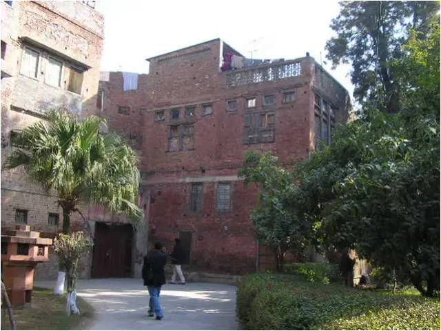
Amritsar does not have its own style of architecture. It has always been borrowed from elsewhere because the people who came and settled here were from different places. Moreover it has been through so many different periods and has had gone through socio-political changes so many times, that they have all left their imprints in the architectural history of Amritsar. One can actually note the differences in the architectural styles of the different periods. Earlier the architecture used to be influenced mainly by the Rajasthani style. With lots of jharokas, decorative motifs and carvings. Later with the advent of Mughals, people started to use elements like the domes and the minars but these were slightly modified. For example, the domes would be fluted. The British brought with them pediments, colonnaded verandas and entrance porches. The modern style exploited new materials and also gave a new vocabulary to the architecture of Amritsar.
- A stark contrast between the old and the new can be seen.
- Earlier, the buildings would present a highly decorative façade with elements like jharokhas, recessed arches and chchatris breaking the façade.
- Now building facades seem to play with massing in general. Solids and voids used in an interesting manner give a different dimension to the building.
- New materials have also come. Reinforced concrete seems to have taken over the traditional brick buildings.
Recreational and Religious Centres
The city does not have much on the recreational front. There are a few parks like the Rambagh which not only serve as the lungs of the city but also act as a pleasant and peaceful breather from the polluted city environment. There is hardly any night life there except for the Lawrence Road which is also known as the Mall Road and which houses cinema theatres and shopping plazas. Although it is a centre of Sikh pilgrimage, one will find worship places of all religions from churches, to mosques to temples.
Important buildings
- Golden Temple Complex
- Khalsa College
- The Golden temple
Golden temple, the soul reason for the existence of the city of Amritsar is located centrally and the whole city has evolved around it. Through the ages, in all the periods, it has got special attention from all the rulers, ranging from being just a ‘sarover’ to getting made of gold.
Today, Amritsar is called the golden city because of the golden temple.
Khalsa college
Being on the Nationl highway to lahore,
Originally maharaja Ranjit Singh’s palace, khalsa college is located on the main road. It is a huge complex. After partition it was converted into a college. Guru Nanak Dev university came up right next to it in the early 20th century.
Economic Base
Major occupations are agriculture, cloth business and service. The major industries of Amritsar are:
- Textile including woolens
- Silk industry
- Cotton industry and Cotton wading
- Carpet manufacture
- Ivory goods and wood work
- Distillery
- Leather Tanning
- Flour mills
- Metal industry including brass, copper and iron
Most of the markets are in core area like salt market, timber market, and grain market. Some of the important centers are: Wholesale yarn trade centre at Katra Ahluwalia, jewellery at Guru Bazar and silk market at Bazar Sabunian
Still the city has maintained and strengthened its position as the major trade center of Punjab, J&K and H.P. The commercial importance may be gauged from the fact that, according to 1971 census, 24% of its working force was employed in trade and commerce. Its future as the premier city of the state may seem to be ensured by its past.
Culture
PROBLEMS AND ISSUES
- Lack of functional relationship
- Unplanned growth of commerce
- High densities
- Movement of transportation
- Mixed traffic
- Vehicular verses pedestrian
- Lack of open spaces and recreational spaces
- Non-compatible uses
- Protection to residential area
- Environmental pollution
“A city is a place that is large enough to sustain Itself in all its undertakings but not so large that its inhabitants lose communication with each other”. – Aristotle
Leave a Reply
You must be logged in to post a comment.